

FREE DELIVERY ON ORDERS OVER £25
ALWAYS UP TO 70% OFF RRP
SIGN UP FOR OFFERS AND EXCLUSIVES


UK in Maps (Collins Primary Atlases) (Paperback)
Stephen Scoffham (Author)
- £4.00
-
£7.99 - £4.00
- Unit price
- per
Save £3.99
Please hurry! Only 23 left in stock
10 customers are viewing this product
Couldn't load pickup availability
Free Shipping
Free standard shipping on orders over £25
Same day dispatch.
Free Returns
Learn More.

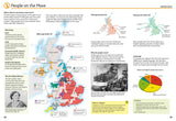
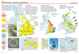
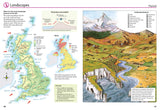
This multi-topic atlas of the UK introduces the most relevant topics to reflect the Geography Key Stage 2-3 requirements of the National Curriculum.
This collection of maps can be used to investigate different themes and topics. It tells a story in maps, diagrams, charts, words and photographs each of which presents information to compare and examine. Ideal for age 8+, with free downloadable activities.
We live on a remarkable planet and this atlas helps us to make sense of the UK today and understand how things came to be as well as how they might change in years to come.
Suggested activities on each spread encourage users to explorer further. Explore the range with World in Maps also available.
- Publisher: Collins
- ISBN: 9780008271732
- Pages: 56
- Weight: 0.234
Stephen Scoffham is Honorary Publications Officer for the Geographical Association (GA) and editor of the GA's best-selling publication, the Primary Geography Handbook
Related Products
Example product title
- £4.00
-
£7.99 - £4.00
- Unit price
- per
Save £3.99
Example product title
- £4.00
-
£7.99 - £4.00
- Unit price
- per
Save £3.99
Example product title
- £4.00
-
£7.99 - £4.00
- Unit price
- per
Save £3.99
Example product title
- £4.00
-
£7.99 - £4.00
- Unit price
- per
Save £3.99
Example product title
- £4.00
-
£7.99 - £4.00
- Unit price
- per
Save £3.99
Example product title
- £4.00
-
£7.99 - £4.00
- Unit price
- per
Save £3.99
Example product title
- £4.00
-
£7.99 - £4.00
- Unit price
- per
Save £3.99
Example product title
- £4.00
-
£7.99 - £4.00
- Unit price
- per
Save £3.99
Example product title
- £4.00
-
£7.99 - £4.00
- Unit price
- per
Save £3.99
Example product title
- £4.00
-
£7.99 - £4.00
- Unit price
- per
Save £3.99
Recently Viewed Products
Example product title
- £4.00
-
£7.99 - £4.00
- Unit price
- per
Save £3.99
Example product title
- £4.00
-
£7.99 - £4.00
- Unit price
- per
Save £3.99
Example product title
- £4.00
-
£7.99 - £4.00
- Unit price
- per
Save £3.99
Example product title
- £4.00
-
£7.99 - £4.00
- Unit price
- per
Save £3.99
Example product title
- £4.00
-
£7.99 - £4.00
- Unit price
- per
Save £3.99
Example product title
- £4.00
-
£7.99 - £4.00
- Unit price
- per
Save £3.99
Example product title
- £4.00
-
£7.99 - £4.00
- Unit price
- per
Save £3.99
Example product title
- £4.00
-
£7.99 - £4.00
- Unit price
- per
Save £3.99
Example product title
- £4.00
-
£7.99 - £4.00
- Unit price
- per
Save £3.99
Example product title
- £4.00
-
£7.99 - £4.00
- Unit price
- per
Save £3.99
- Choosing a selection results in a full page refresh.