FREE DELIVERY ON ORDERS OVER £25
ALWAYS UP TO 70% OFF RRP
SIGN UP FOR OFFERS AND EXCLUSIVES


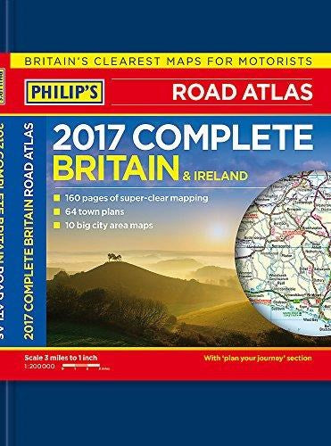
Philip's Complete Road Atlas Britain and Ireland 2017: Hardback (Hardback)
Philip's Maps (Author)
- £8.00
-
£19.99 - £8.00
- Unit price
- per
Couldn't load pickup availability
Free Shipping
Free standard shipping on orders over £25
Same day dispatch.
Free Returns
Deluxe hardback edition - perfect for a gift.
Philip's: Britain's clearest maps for motorists.
Completely updated and revised for 2017.
"Good balance between detail and quality ... excellent town maps" What Car?
160 pages of fully updated road maps.
2-page road map of Ireland.
64 indexed town-centre maps.
14 pages of city approach maps with named arterial roads.
10 pages of detailed route-planning maps, incorporating a key map.
Hardback atlases are popular as gifts and also for self-purchase by heavy users such as business drivers.
Philip's Complete Road Atlas Britain and Ireland 2017 is a mid-format deluxe hardback atlas featuring fully updated maps from the Philip's digital database, which has been voted Britain's clearest and most detailed in an independent consumer survey.
Philip's Complete Road Atlas Britain and Ireland 2017 contains 160 pages of road maps covering Britain at 3 miles to 1 inch, with the Western Isles, Orkney and Shetland at smaller scales. The maps clearly mark service areas, roundabouts and multi-level junctions, and in rural areas distinguish between roads over and under 4 metres wide - a boon for drivers of wide vehicles.
The atlas also includes a 2-page road map of Ireland, 10 pages of route-planning maps, a distance table, 10 large-scale city approach maps with named arterial roads, and 64 extra-detailed and fully indexed town and city plans.
- Publisher: Philip's
- ISBN: 9781849074131
- Pages: 248
- Weight: 1.13
Related Products
- £8.00
-
£19.99 - £8.00
- Unit price
- per
- £8.00
-
£19.99 - £8.00
- Unit price
- per
- £8.00
-
£19.99 - £8.00
- Unit price
- per
- £8.00
-
£19.99 - £8.00
- Unit price
- per
- £8.00
-
£19.99 - £8.00
- Unit price
- per
- £8.00
-
£19.99 - £8.00
- Unit price
- per
- £8.00
-
£19.99 - £8.00
- Unit price
- per
- £8.00
-
£19.99 - £8.00
- Unit price
- per
- £8.00
-
£19.99 - £8.00
- Unit price
- per
- £8.00
-
£19.99 - £8.00
- Unit price
- per
Recently Viewed Products
- £8.00
-
£19.99 - £8.00
- Unit price
- per
- £8.00
-
£19.99 - £8.00
- Unit price
- per
- £8.00
-
£19.99 - £8.00
- Unit price
- per
- £8.00
-
£19.99 - £8.00
- Unit price
- per
- £8.00
-
£19.99 - £8.00
- Unit price
- per
- £8.00
-
£19.99 - £8.00
- Unit price
- per
- £8.00
-
£19.99 - £8.00
- Unit price
- per
- £8.00
-
£19.99 - £8.00
- Unit price
- per
- £8.00
-
£19.99 - £8.00
- Unit price
- per
- £8.00
-
£19.99 - £8.00
- Unit price
- per
- Choosing a selection results in a full page refresh.


